
News
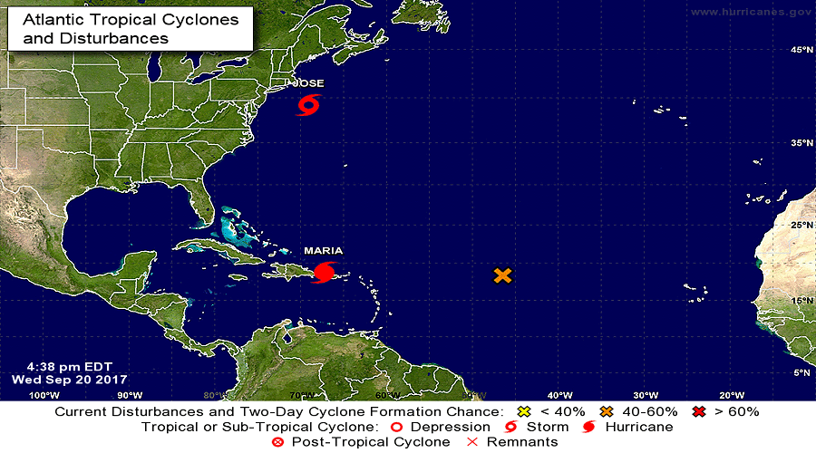
Hurricane Maria Advisory Number 19
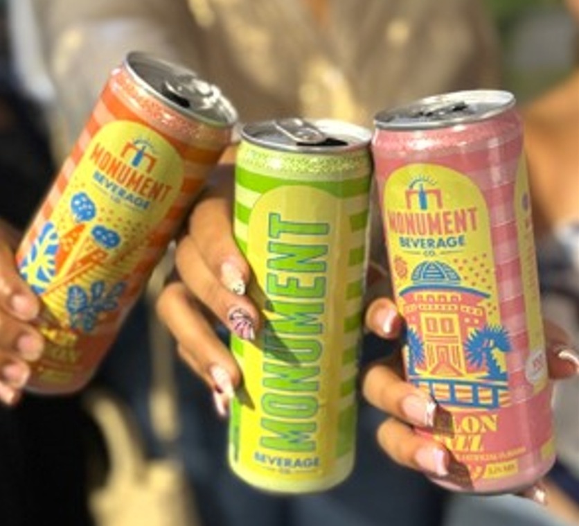
NASSAU, Bahamas — Caribbean Wines & Spirits (CWS), The Bahamas’ premier wines and spirits distributor is proud to announce the launch of Monument Beverage Co., its newest 100% locally produced ready-to-drink alcoholic cocktail.
Monument, “Made to Celebrate”, perfectly encapsulates everything the brand represents. Created and distributed by CWS, Monument is inspired by culture, crafted with excellence and bursting with innovation.
This unique beverage celebrates island living with three bold flavors, Ginger Lime, Peach Passion and Melon Fizz. All of which can be enjoyed at an ABV of five-point-two percent.
The brand’s creativity really shines through each can’s packaging. Bold colored stripes, cherished native flora and fauna and of course, national monuments can all be found on each can.
The beverage’s two year plus development is a testament to CWS’ dedication to quality and innovation. Countless hours of tastings, reformulations, focus groups and package design reviews all paid off with the creation of Monument.
Karla Wells-Lisgaris, Chief Commercial Officer of Caribbean Wines & Spirits and Caribbean Bottling Company (CBC), local producers of Coca-Cola and Dasani products, shared what this authentically Bahamian made product launch means for the company.
“When we were conceptualizing Monument, we wanted to create a product that not only tasted like The Bahamas but would be an ode to the nation as well. With those two thoughts in mind, I, along with a team of experts, created three incredible flavors we believe really connect with and celebrate the essence of island living,” she said.
“Additionally, being that Monument is the first product to be 100% manufactured by Caribbean Wines & Spirits, we really wanted to ensure that both the flavors and packaging honored our rich heritage. On each of the cans, you can find various monuments such as the Nassau Public Library in New Providence, the Garden of the Grove in Grand Bahama and the Hatchet Bay Silos in Eleuthera; all of which pay homage to our diverse Bahamian heritage.” Wells-Lisgaris concluded.”
The historic monuments found throughout our islands are more than places we pass every day; they are reminders of who we are, where we’ve come from and the stories that connect us as Bahamians.
Monument is perfectly formulated with quality ingredients, and each can celebrates a collection of these cultural icons from across The Bahamas.
Whether chilling solo beachside, gathered around a family table or backyard a grill with friends, make Monument your sip of choice. Monument is made to celebrate, visit www.cwsbahamas.com today for more details.
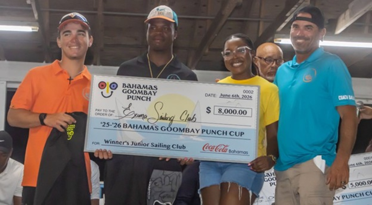
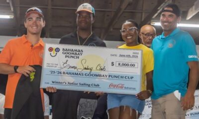
NASSAU, Bahamas —– Caribbean Bottling Company (CBC), local producers of Coca-Cola and Dasani products, is proud to crown Lady Kayla of Exuma as this year’s annual Bahamas Goombay Punch Cup winner.
CBC created the Bahamas Goombay Punch Cup to further the advancement of sailing and Bahamian culture through monetary and social support. The competition judges the skipper’s performance across three regattas, The Best of the Best, the National Family Island and Long Island Regattas.
The winning sloop led by Kianno Hutchinson and Joss Knowles showcased their skillmanship in the E-Class category across each round of competition. In addition to winning the trophy, the skippers were awarded a $5,000 donation, an $8,000 stipend to the junior sailing club of their island and a limited-edition Lady Kayla Bahamas Goombay Punch commemorative can, which will be released soon.
Jonathan Thronebury, Marketing Director of CBC shared the significance behind The Bahamas Goombay Punch Cup.
“The Bahamas Goombay Punch is more than a beloved local brand; it’s a vibrant part of our cultural fabric. Just like sailing, our national sport, it carries a rich legacy that spans generations. Recognizing this shared history, we’re proud to support initiatives that celebrate and advance Bahamian culture,” he said.
Hutchinson and Knowles shared what this win meant for them.
“I felt super proud when I realized we won. I am grateful and thankful to God, for good coaches and Joss. It was really an honor winning the Bahamas Goombay Punch Cup,” Hutchinson expressed.
“I am very honored to have been able to compete in the Bahamas Goombay Punch Cup, I think it is a great concept and idea for a competition and really adds a new motive throughout the regattas. The whole championship was super competitive, and every single race was a fight. Alvington McKenzie was extremely competitive and had us until the Long Island regatta, which made it a very fun and tough competition. Very excited to have been the winner of a super close championship,” Knowles revealed.
Lady Kayla’s owner, Dallas Knowles, shared the team’s winning strategy.
“In sailing consistency is key and our guys in Lady Kayla are some of the best in the business at staying near the top. In the end, that was enough to secure their first Bahamas Goombay Punch Cup win. We are so proud of Joss and Kianno for what they have done in Lady Kayla. Thank you to Caribbean Bottling Company for such an amazing and forward-thinking initiative,” Knowles shared.
The Bahamas Goombay Punch Cup is proud to continue its impact on sailing and community building through clean and fair competition.
For more updates on the Bahamas Goombay Punch Cup and Caribbean Bottling Company visit the website www.cbcbahamas.com today.
News
Minister of Tourism, Hon. Zhavargo Jolly Leads Community Connect Meetings in Grand Turk and Salt Cay

Providenciales, Turks and Caicos Islands (July 31st, 2026) – Experience Turks and Caicos, in collaboration with the Ministry of Tourism, has relaunched its Community Connect initiative, reaffirming its commitment to ensuring residents play a central role in shaping the future of tourism across the Turks and Caicos Islands. The meetings began in Grand Turk and Salt Cay, marking the first in a series of engagements that will be held across the country.
Led by the Minister of Tourism, Hon. Zhavargo Jolly, the meetings were held on Monday, July 27th, and Tuesday, July 28th, respectively at the Yellowman and Sons Auditorium in Grand Turk and the Salt Shed in Salt Cay.
Community Connect is a series of town hall meetings designed to keep communities informed about the work of Experience Turks and Caicos and the Ministry of Tourism, provide updates on the performance of the tourism industry, and create an open forum where residents can share their concerns, ideas and recommendations for strengthening the tourism product. The initiative reflects the Ministry’s commitment to ensuring tourism development is informed by the voices of the communities it is intended to benefit.
The meetings brought together residents, business owners and tourism stakeholders for open and insightful discussions about the future of tourism on their respective islands. Participants engaged directly with Hon. Jolly and his team, which included Deputy Permanent Secretaries Mr. Arthur Been and Mr. Ronlee James, along with Experience Turks and Caicos Product Development Manager Mrs. Candesha Mills.
Opening the meetings, Hon. Jolly stressed that Community Connect is intended to be a conversation rather than a presentation, giving residents an opportunity to help shape the future of tourism in their communities.
“We are hoping to have a dialogue about the future of tourism in Grand Turk. We want to ensure residents are prepared to take advantage of the opportunities that tourism creates, while also understanding the challenges you see, whether it is cruise tourism development or other issues, so that together we can address those gaps and better prepare our people to benefit,” he said in his welcome address in Grand Turk.
Discussion in Grand Turk covered a wide range of issues, including garbage collection, the culling of donkeys and stray dogs, hotel investment, airlift and the continued development of the island’s tourism sector.
The meeting also featured brief remarks by Mr. Donte Francis of the Grand Turk Enhancement and Sustainability Agency (GTESA), who provided an update on projects completed and those currently in the pipeline. He noted that GTESA has completed 22 projects to date and is awaiting Board approval for an additional 14 initiatives.
In Salt Cay, discussions focused largely on community infrastructure and essential services that, while not directly tourism-related, play an important role in supporting the visitor experience and the island’s long-term tourism potential. Residents raised concerns about the frequency of flights and ferry service to Grand Turk, the absence of ambulance and emergency medical services, and ongoing water supply challenges.
Reflecting on the discussions, Hon. Jolly reaffirmed his commitment to working closely with communities to ensure they play an active role in shaping the future of tourism.
“As I shared during the meetings, our communities have the power to help shape how their islands develop. My responsibility as Minister is to listen, understand the challenges they face, and ensure my Ministry is doing everything possible to create opportunities and remove barriers. I was encouraged by the honest and constructive discussions we had in both Grand Turk and Salt Cay, and I look forward to continuing this conversation across the Turks and Caicos Islands. I want to thank everyone who took the time to attend and share their views.”
Community Connect will continue in the coming months with meetings in North, Middle and South Caicos, as well as communities across Providenciales.


-

 Bahamas News4 days ago
Caribbean Bottling Supports the 27th Basketball Smiles Week
-
 Bahamas News7 hours ago
Lady Kayla Crowned Goombay Punch Cup Sailing Champion of 2025/2026
-
 Bahamas News4 days ago
CWS Supports Transforming Spaces with Premium Products and Unique Cocktails
-

 Bahamas News6 hours ago
Monument Beverage Co. Caribbean Wines & Spirits Uniquely Bahamian Newest Product
-

 News2 days ago
Minister of Tourism, Hon. Zhavargo Jolly Leads Community Connect Meetings in Grand Turk and Salt Cay