
Weather
TD #9 gets a name; Tropical Storm Isaias forms packing 60mph winds
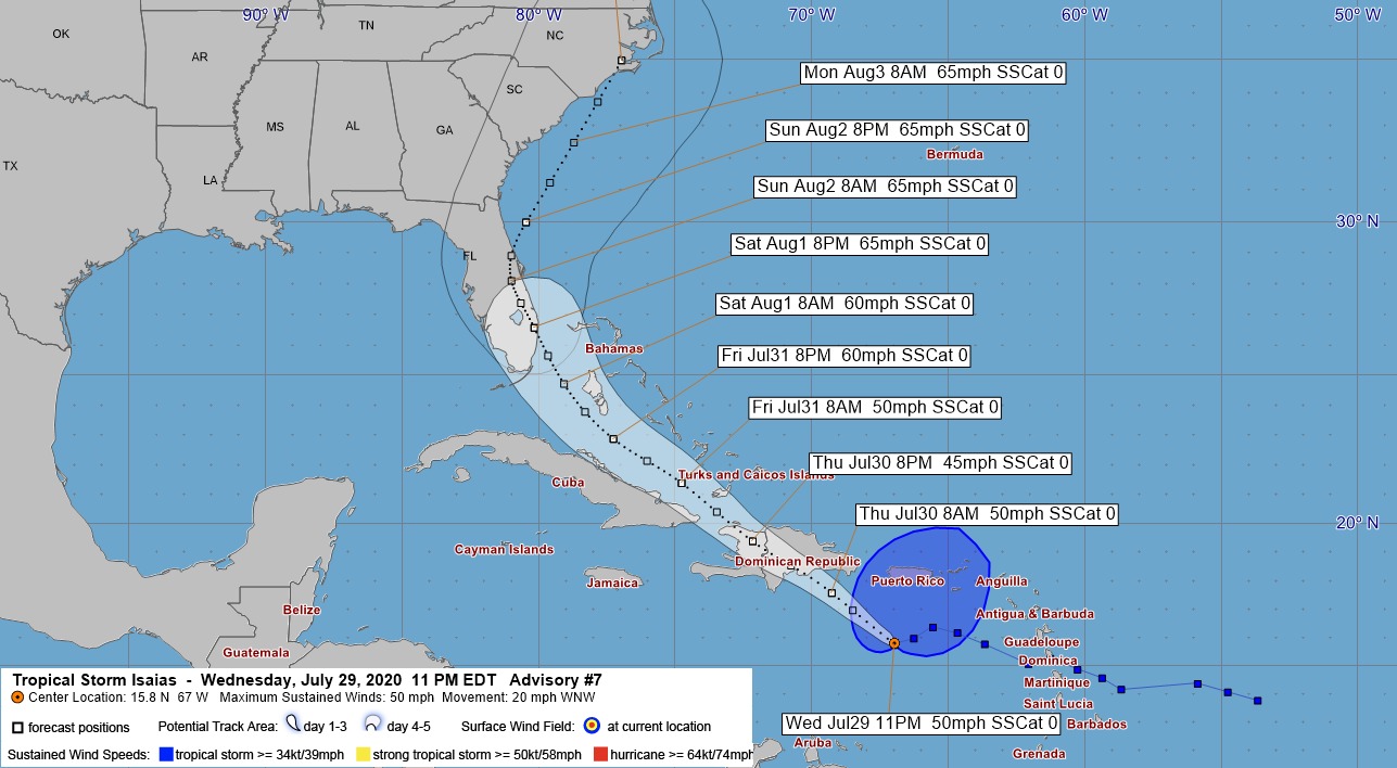
#AtlanticBasin – July 30, 2020 – Tropical Depression number nine, forecast to become the earliest ‘I’ named storm in history has finally earned that name: Isaias. In the wee hours of Thursday morning, TD#9 evolved from a tropical depression to a Tropical Storm with wind gusts up to 60 mph.
The National Hurricane Center, at 2 a.m. informed that Puerto Rico should expect strong rain bands from the tropical storm which has triggered storm watches and warnings for at least 10 Caribbean region countries.
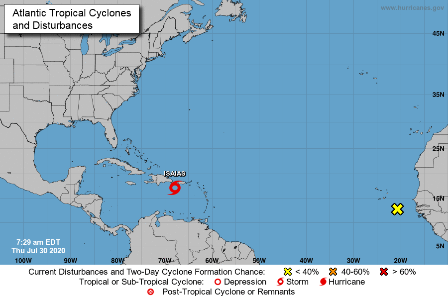
Tropical Storm Isaias slowed from racing across the region at nearly 30 mph to now pacing at 21 mph in a north-westerly direction. Hispaniola, home to Haiti and the Dominican Republic will experience storm conditions this morning and worse, the storm could become a killer.
“Isaias will produce heavy rains and potentially life-threatening flash flooding and mudslides across the Virgin Islands, Puerto Rico, the Dominican Republic, northern Haiti, and over the southeastern Bahamas.”
The Turks and Caicos Islands, which has been on Tropical Storm Watch since Wednesday at 12 a.m. has announced a national lockdown by noon Thursday and shelters are due to open at 4pm.
The southeastern Bahamas will experience conditions on Thursday afternoon and the central Bahama islands are predicted to shoulder powerful 60 mph wind conditions throughout the day on Friday.
“Tropical storm conditions are expected in the Central Bahamas beginning Friday morning and are possible in the northwestern Bahamas beginning late Friday.”

The National Hurricane Center advisory informs that British Virgin Islands, U.S. Virgin Islands, Puerto Rico, northern Haiti, Dominican Republic, Turks and Caicos and eastern Cuba will receive between three and six inches of rain.
Even higher rainfalls are forecast for The Bahamas; from four to eight inches. Life threatening surf and rip currents are expected from today due to approaching Tropical Storm Isaias.
“Swells generated by Isaias will be affecting portions of the Leeward Islands, the Virgin Islands, and Puerto Rico through today. These swells are forecast to reach the north coast of the Dominican Republic, the Turks and Caicos Islands and the southeastern Bahamas this morning.”
The National Hurricane Center, in the latest advisory informs:
The Tropical Storm Warning for St. Martin, St. Barthelemy, St.
Maarten, Saba and St. Eustatius has been discontinued.
SUMMARY OF WATCHES AND WARNINGS IN EFFECT:
A Tropical Storm Warning is in effect for…
* Puerto Rico, Vieques, Culebra
* U.S. Virgin Islands
* British Virgin Islands
* Dominican Republic entire southern and northern coastlines
* North coast of Haiti from Le Mole St Nicholas eastward to the
northern border with the Dominican Republic
* Turks and Caicos Islands
* Southeastern Bahamas including the Acklins, Crooked Island, Long
Cay, the Inaguas, Mayaguana, and the Ragged Islands
* Central Bahamas, including Cat Island, the Exumas, Long Island,
Rum Cay, and San Salvador
A Tropical Storm Watch is in effect for…
* Northwestern Bahamas including Andros Island, New Providence, Eleuthera, Abacos Islands, Berry Islands, Grand Bahamas Island, and Bimini
Interests in Cuba and the Florida peninsula should monitor the progress of this system.
A Tropical Storm Warning means that tropical storm conditions are expected somewhere within the warning area within 36 hours. A Tropical Storm Watch means that tropical storm conditions are possible within the watch area, generally within 48 hours.


A week of wind, water, and heartbreak
From Haiti’s hillsides to Bermuda’s reefs, seven Caribbean nations have been battered, bruised, and forever marked by Hurricane Melissa — a storm that tested not only the region’s infrastructure but its unshakable spirit of unity.
Saturday–Sunday, October 25–26 – The First Strike: Hispaniola
Before the storm even earned its name, torrential rain and flash floods swept across Haiti and the Dominican Republic, claiming lives and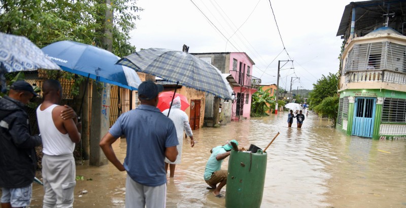 tearing through rural communities.
In southern Haiti, rivers burst their banks, swallowing roads and homes; 23 people were confirmed dead by Sunday evening. Across the border, one death was reported in the Dominican Republic as swollen rivers cut off villages in Barahona and Pedernales.
By nightfall, the tropical system had strengthened — and the Caribbean knew it was facing something historic.
Monday, October 27 – Evacuations and Airlifts
In The Bahamas, Prime Minister Philip Davis issued a mandatory evacuation for the MICAL Islands — Mayaguana, Inagua, Crooked Island, Acklins, Long Cay, and Ragged Island.
Bahamasair added extra flights as the nation braced for what forecasters warned could become the strongest storm in nearly two decades.
Meanwhile, Jamaica, Turks & Caicos, and Cuba activated their national emergency operations centers.
Tuesday, October 28 – Jamaica and Haiti Hit Hard
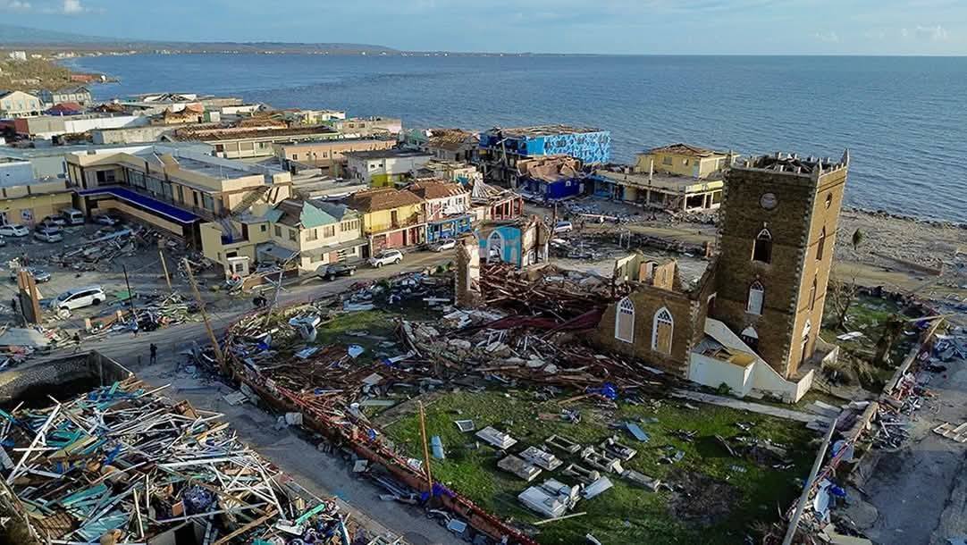
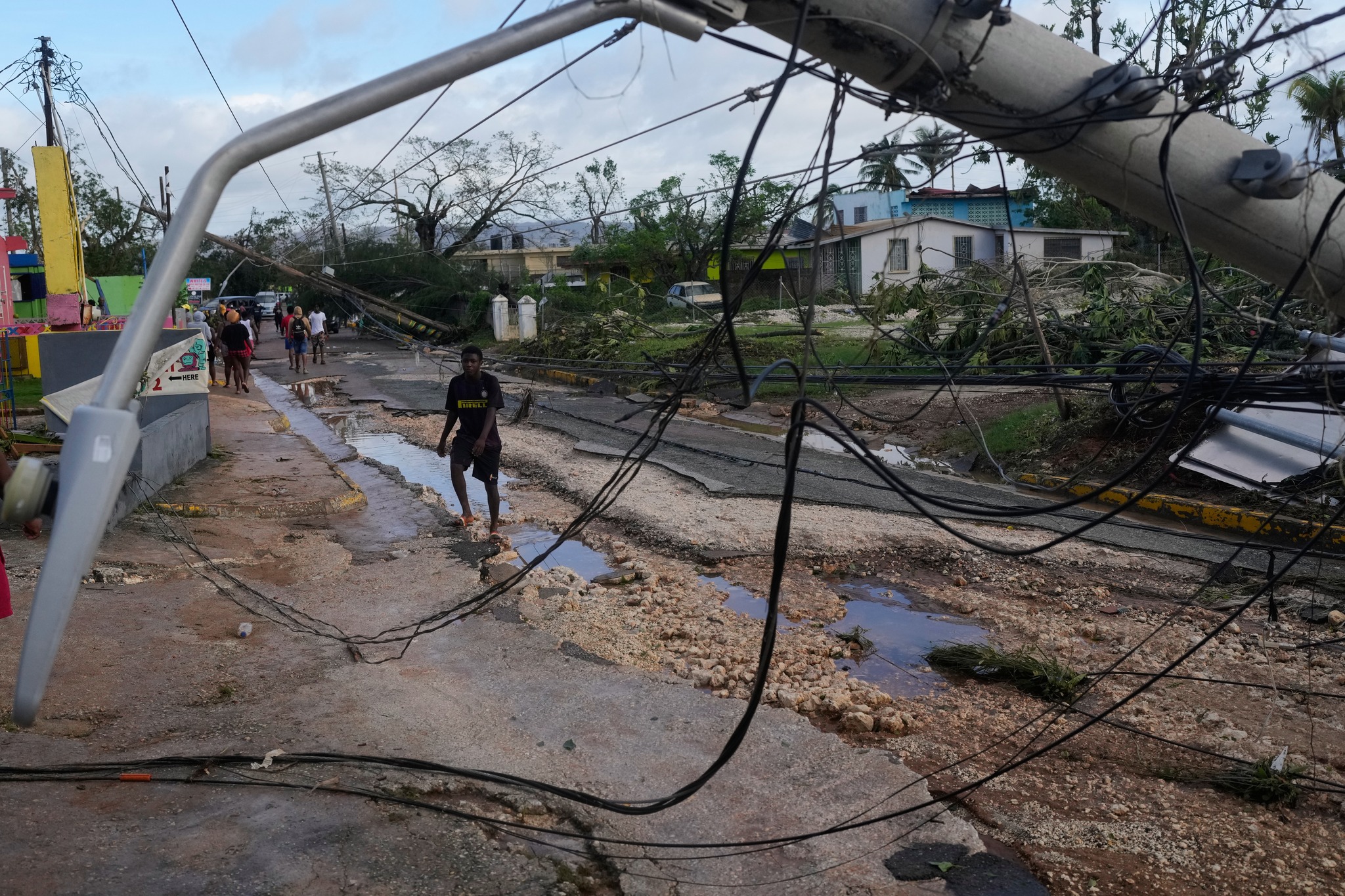
By afternoon, Hurricane Melissa made landfall near St Elizabeth, Jamaica, as a Category 5 hurricane — winds of 185 mph, central pressure 892 mb, the lowest ever recorded so close to the island.
Roads collapsed, bridges washed away, and Black River Hospital lost its roof. Power failed for 72 percent of the island.
BOJ TV footage shows split asphalt, sparking lines, and flooded communities abandoned for safety.
Initially four were reported dead, that grew to seven deaths and heavy damage in 170 communities; Andrew Holness, Jamaican Prime Minister calling it “a national test of resilience.”
Haiti, still recovering from the weekend’s flooding, was hit again as outer bands dumped more rain on Les Cayes and Jacmel, deepening the humanitarian crisis.
Wednesday, October 29 – Crossing to Cuba
Weakened slightly to Category 4 (145 mph), Melissa tracked north-northeast at 8 mph, hammering eastern Cuba with hurricane-force winds
and mudslides. Over 15 000 people were evacuated from Santiago de Cuba and Holguín.
In Turks & Caicos, the Regiment deployed to Grand Turk, Salt Cay, South, North and Middle Caicos, preparing shelters and securing public buildings.
Thursday, October 30 – The Bahamas and the All Clear
Melissa’s speed increased, sparing the northern Caribbean its worst.
The Bahamas Airport Authority closed 13 airports from Mayaguana to Exuma International; none reported casualties, though infrastructure suffered.
In Turks & Caicos, the all-clear came early Thursday after minimal impact. Premier Washington Misick expressed gratitude and pledged support for neighbors:
“We must act — not only with words, but with compassion and deeds.”
Friday, October 31 – Counting the Cost
By Friday, Melissa had weakened to Category 3 (120 mph) north of Cuba.
The Bahamas Department of Meteorology issued its final alert, lifting warnings for the southern islands.
Regional toll:
- Haiti: 23 dead, thousands displaced.
- Jamaica: 7 dead, 170 communities damaged; 72% without electricity
- Cuba: 2 dead, 15, 000 evacuated.
- Dominican Republic: 1 dead, flooding in southwest.
- Bahamas: 0 dead, minor infrastructure damage and flooding in southeast.
- Turks & Caicos: minimal to no impact.
Relief and Reconnection
The Cayman Islands became the first government to touch down in Jamaica post-storm. Premier Juliana O’Connor-Connolly led a contingent bringing a plane-load of essentials and pledged US $1.2 million in aid.
Reggae icon Shaggy arrived on a private jet with friends, delivering food, medical kits, and hygiene supplies.
Meanwhile, Starlink and FLOW Jamaica activated emergency satellite internet across Jamaica providing free connectivity through November.
From overseas, U.S. President Donald Trump, speaking during his Asia tour, announced that American search-and-rescue teams and disaster aid will support the region.
“They can depend on U.S. assistance as they recover from this historic storm,” he said.
Faith, Funds, and False Websites
The Government of Jamaica and the Sandals Foundation have both launched verified donation portals for recovery. Officials are warning against fake crowdfunding pages posing as relief sites and urging donors to use only official channels.
A Seventh Nation in the Crosshairs – Bermuda
As Hurricane Melissa left the Caribbean basin, Bermuda found itself next in line.
Forecasts indicated the storm would pass just west of the island late Thursday into Friday, likely as a Category 1 to 2 hurricane with sustained winds near 105 mph.
Though far weaker than when it ravaged Jamaica, officials issued a hurricane warning, urging residents to secure property and expect tropical-storm conditions.
By all appearances Bermuda is heeding the warnings
The Human Response
Across the Caribbean, solidarity surged.
The Global Empowerment Mission (GEM) in Miami began airlifting relief supplies, while churches, civic groups, and businesses in The Bahamas and Turks & Caicos organized drives for displaced families.
“Your dedication gave our islands the strength to face the storm,” Premier Misick said. “Together, as one Caribbean family, we will rise stronger.”
Resilience in the Wake
Melissa’s winds may have faded, but her impact endures. Engineers are inspecting bridges, hillsides, and water systems; volunteers are clearing debris and distributing aid in communities still cut off.
From Haiti’s ravaged river valleys to Jamaica’s sugar towns, from Cuba’s eastern hills to The Bahamas’ salt ponds and Bermuda’s reefs, the region once again stands at the crossroads of ruin and renewal — and leans, as always, toward hope and a faithful God
Deandrea Hamilton | Editor
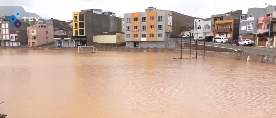
August 15, 2025 – At least nine people, including four children, were killed in flash flooding on the island of São Vicente, Cabo Verde, when the storm that would become Hurricane Erin swept through the West African archipelago last week. Authorities there say another five remain missing and more than 1,500 residents were displaced after torrential rains inundated homes and swept vehicles from the streets.
Now a major hurricane over the Atlantic, Erin has moved past the Leeward Islands, the British Virgin Islands, and the U.S. Virgin Islands, where residents endured heavy rain, gusty winds, and rough seas over the weekend. The Antigua and Barbuda Meteorological Services has issued an official all clear for the Leeward and British Virgin Islands, though forecasters caution that flood watches, high surf, and rip current risks remain in place.
Damage assessments from the Virgin Islands are still under way, with reports of localized flooding, power outages, and disrupted transport. No fatalities have been reported in the Caribbean to date.
Attention has now shifted to the Turks and Caicos Islands, which are beginning to feel tropical storm conditions as Erin tracks northwest. Heavy rainbands and gusty winds are expected to continue there into Monday, bringing the potential for flooding and coastal erosion.
Meanwhile, in The Bahamas, a Tropical Storm Watch has been issued, with forecasters warning of heavy rainfall, dangerous seas, and possible tropical-storm-force winds later this week. Travelers to both The Bahamas and Turks and Caicos are being urged to monitor advisories closely, check travel plans with airlines and hotels, and follow local safety instructions.
Caribbean News
Rain, Dust, and Rising Heat: Signs Point to a Wetter, Wavier August in TCI and The Bahamas

Deandrea Hamilton | Editor
August 1, 2025 – The Turks and Caicos Islands and The Bahamas are entering a pivotal weather phase as tropical moisture is expected to bring rain from Monday through Wednesday, signaling a shift in conditions despite no tropical cyclone currently affecting the region. Forecasters, including several YouTube weather analysts, have flagged this transition—not as a storm, but as a notable uptick in rainfall associated with atmospheric waves approaching the southwest Atlantic.
This change is arriving alongside a forecasted plume of Saharan dust, set to drift westward early next week. That dry, dusty air layer is notorious for reducing cloud cover, suppressing rainfall in the early season, and limiting tropical storm formation. When it arrives, skies will turn hazy, air quality may decline to moderate levels, and visibility will lower, even while thermometers remain elevated.
Meanwhile, long-range models from the U.S. Climate Prediction Center flag the Atlantic and eastern Gulf corridor from August 6– 12 as the first period this season with increased chances—albeit still low—of tropical development. Historically, August marks the escalation of hurricane formation, making the coming weeks especially important for vigilant monitoring. As of August 1, 2025, three named storms have already formed in the Atlantic: Alberto, Beryl, and Chris. The remaining names for the 2025 Atlantic hurricane season are: Debby, Ernesto, Florence, Gordon, Humberto, Idalia, Jose, Katia, Lee, Margot, Nigel, Ophelia, Pablo, Rebekah, Sebastien, Tanya, and Victor.
At present, no systems in the Pacific basin are forecasted to affect Puerto Rico, the Turks and Caicos Islands, or The Bahamas. The eastern Pacific remains active, but no cross-basin moisture or disturbances are expected to cross into our region.
In summary, residents should brace for a few days of elevated rain chances in early August, under skies tinged with dust and variable sunshine. While the Atlantic remains largely quiet today, a gradual shift toward wetter, more unstable weather is underway, and early to mid-August may well mark the true start of the season’s active phase. Stay tuned for updated alerts and official forecasts as conditions evolve.
Photo Caption: MrWeatherman/YouTube


-

 Africa1 week ago
Bahamas’ Ghana Teacher Plan Draws Fire as Both Nations Face Shortages
-

 News1 week ago
Ministry of Health Welcomes Appointment of New NHIB Chief Executive Officer and Highlights Progress of Organisational Transformation
-

 News1 week ago
Invest TCI Supports Certification of Local Flats Fishing Guides Through MSME Technical Assistance Under Historic TCFFA–TCICC Partnership
-

 News1 week ago
DDME’s Hurricane Hunt Scavenger Hunt Sparks Community Spirit and Storm Preparedness in Providenciales
-

 News1 week ago
Government Takes Case to Washington After U.S. Keeps TCI at Level 2
-

 News1 week ago
PDM Alleges Governor ‘Bias’, Opposes One-Year Extension
-

 Bahamas News1 week ago
What 45 Shell Casings and New Murder Charges May Mean for Three Officers in the Azario Major Case
-

 Bahamas News1 week ago
CARICOM Targets Affordability as Bahamas, TCI Continue to Feel the Pinch