Connect with us

Weather

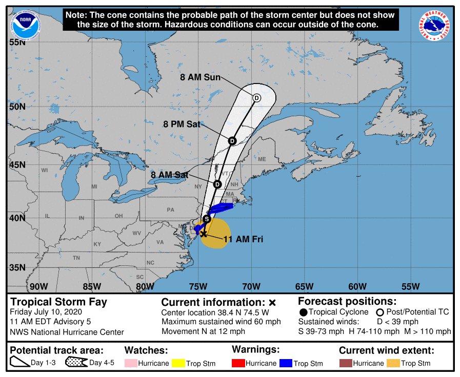
TROPICAL STORM WARNINGS CONTINUE FOR THE DELAWARE COASTLINE
Published

on

AT 11:00 AM EDT, THE CENTER OF TROPICAL STORM FAY WAS LOCATED NEAR LATITUDE 37.6° NORTH AND LONGITUDE 74.7° WEST OR 85 MILES SOUTH OF OCEAN CITY, MARYLAND.

FAY IS MOVING TOWARD THE NORTH NEAR 10 MILES PER HOUR. A NORTHWARD TO NORTH-NORTHEASTWARD MOTION AT A FASTER FORWARD SPEED IS EXPECTED FOR THE NEXT COUPLE OF DAYS.

MAXIMUM SUSTAINED WINDS ARE NEAR 50 MILES PER HOUR WITH HIGHER GUSTS. LITTLE CHANGE IN STRENGTH IS FORECAST TODAY AND TONIGHT WHILE THE CENTER REMAINS OVER WATER. WEAKENING SHOULD BEGIN AFTER THE CENTER MOVES INLAND.

THE NEXT NEWS ITEM WILL BE ISSUED AT 6PM.PREPARED BY DUTY FORECASTER: GREGORY D. THOMPSON (CCO)10TH JULY 2020 @ 11:45 AM    

Magnetic Media is a Telly Award winning multi-media company specializing in creating compelling and socially uplifting TV and Radio broadcast programming as a means for advertising and public relations exposure for its clients.

Continue Reading

Caribbean News

Caribbean Climate Outlook points to Extreme Weather until December

Published

on

Garfield Ekon
Staff Writer


Barbados, September 4, 2024 – The Barbados-based Caribbean Climate Outlook Forum (CariCOF) says cooling temperatures in the equatorial Pacific may possibly result in a progressive transition to La Niña while near record warm Tropical North Atlantic Ocean are set to continue.

In its outlook for the period September to December, CariCOF said though unpredictable conditions in the atmosphere can, at times, present barriers to extreme activity of these three types of seasons, they are unlikely to persist throughout the period.

It said during the period May to July this year, a record-warm Tropical North Atlantic had continued to fuel record-breaking temperatures, as well as the usual or even larger than the usual rainfall totals during the transition into the Caribbean wet season, including record rainfall in inland Guyana and Suriname.

Nevertheless, long-term drought remains in place in northern Guyana and westernmost Jamaica.

CariCOF said that as of August 1, this year, severe or worse short-term drought has developed in western Jamaica and southwest Trinidad with long-term drought in southwest Belize, French Guiana, northern Guyana, western Jamaica and eastern Suriname.

Long-term drought at the end of November is evolving in French Guiana, and Trinidad, and might possibly develop or continue in western and southeastern Belize, northern Guyana and Tobago.

“An unseasonably warm Tropical North Atlantic, potentially combined with La Niña conditions is forecast. Consequently, unusually high air temperatures and humidity remain likely in many locations, but a steady decrease in heat stress is expected in November as the region transitions into the cool season by December.”

It said  the risk of severe weather impacts from frequent tropical cyclones or other shower activity, including flooding, flash floods, and cascading impacts should be initially high to extremely high through December in Belize and the islands, but subsequently decrease.

Unusually copious rainfall totals are forecast in the Guianas, Jamaica and the Lesser Antilles, CariCOF added.

Continue Reading

Bahamas News

Hurricane 101, the basics for Residents of the Basin

Published

on

Garfield Ekon

Staff Writer


A hurricane is a violent warm-core tropical storm with a minimum wind speed of 119 km or (74 mph) rotating in a counter-clockwise spiral around a region of low pressure called the center of the eye.

The weather pattern between June and December is significantly influenced by the Northward shift of the Inter-Tropical Convergence Zone and cyclonic instability, which leads to the formation of easterly waves, storms, and hurricanes.

While hurricane winds move in a spiraling counterclockwise direction, the hurricane itself moves with the basic motion of the trade winds in which it is embodied.

The official hurricane season starts on June 1 and continues till November 30 annually. The period is usually a rainy one even if a hurricane does not develop.

The Caribbean Disaster Emergency Management Agency (CDEMA), a regional inter-Governmental agency for disaster management in the Caribbean Community (CARICOM), advises that the following disaster supplies be stocked during the season.

Flashlight and extra batteries, portable, battery-operated radio, first aid kit, non-perishable (canned food) and water, non-electric can opener. Essential medicines, and as much cash on hand, to respond to emergencies. Permanent shutters are the best protection. A lower-cost approach is to put up plywood panels. Use 1/2-inch plywood–marine plywood is best–cut to fit each window.

Remember to mark which board fits which window. Pre-drill holes every 18 inches for screws. Do this long before the storm. Trim back branches from trees .Trim branches away from your home and cut all dead or weak branches on any trees on your property.

Check into your Home and Auto Insurance.  Confirm that policies are valid, and coverage is appropriate. Make arrangements for pets and livestock. Pets may not be allowed into emergency shelters for health and space reasons. Contact your local humane society for information on animal shelters.

Develop an emergency communication plan. Make sure that all family members know what to do. Teach family members how and when to turn off gas, electricity, and water. Teach children how and when to call police or fire department and which radio station to tune to for emergency information. In case family members are separated from one another during a disaster (a real possibility during the day when adults are at work and children are at school), have a plan for getting back together.

After a hurricane, persons should seek medical attention at first-aid stations, hospitals or clinics for persons injured during the storm. Do not touch loose or dangling electrical wires. Report these to the power company, the nearest police station or parish council.

Report all broken sewer or water mains directly to the parish council, the public works department or water resources authority for your area. Immediately after the hurricane don’t use stored water for washing houses, cars and watering gardens until normal water services have been restored. Do not empty water stored in bathtubs or other receptacles until safe drinking water is restored.

Boil all drinking water until you are sure that a safe water supply has been restored. Watch out for fallen trees. Collect fallen branches and other debris and pile them where they can be easily collected. Do not go outside barefooted.

Avoid wearing open shoes and watch out for broken glass.

Continue Reading

News

HIGH SURF WARNING ISSUED BY THE TURKS AND CAICOS ISLANDS NATIONAL WEATHER SERVICE 05:00 PM TUESDAY 13 AUGUST 2024

Published

on

Turks and Caicos, August 14, 2024 – Swells generated by Tropical Storm Ernesto are expected to impact the Turks and Caicos Islands by Wednesday afternoon until Thursday evening.

Seas (significant wave height): 7 to 11 feet in easterly swell, occasionally reaching over 11 feet

Surf (breaking swells): Over 10 feet

A high surf warning means that dangerous surfs greater than 10 feet will affect mainly north to east-facing coastlines in the advisory area, producing hazardous marine conditions.

Potential impacts:

  • Dangerous rip currents along Atlantic–facing coastlines

  • Loss of life–strong currents that can carry even the strongest swimmers out to sea

  • High surfs can knock spectators off exposed rocks and jetties.

  • Localized disruptions to marine recreation and businesses

  • Coastal flooding and beach erosion

Beachgoers and small craft operators should be extremely cautious and refrain from entering the waters.

Rip currents are powerful channels of water flowing quickly away from shore, which occur most often at low spots or breaks in the sandbar and near structures such as groins, jetties, and piers. If caught in a rip current, relax and float. Don’t swim against the current. If able, swim in a direction following the shoreline. If unable to escape, face the shore and call or wave for help.

Please continue to monitor these hazardous, life-threatening marine conditions. Stay tuned to updates coming out of the TCINWS via https://buff.ly/3PXdo8f, the TCINWS WhatsApp Broadcast Channel https://buff.ly/4bQzBgy and the DDME Alert App. Also, stay tuned to Radio Turks and Caicos and Power 92.5 FM along with other media platforms for updates.


Forecaster: H. Hamilton

Continue Reading

FIND US ON FACEBOOK

TRENDING