
Caribbean News
NLA and JDF sigh MOU for Hydrographic Surveys of Jamaica

#Kingston, July 4, 2019 – Jamaica – The National Land Agency (NLA) and Jamaica Defence Force (JDF) have signed a Memorandum of Understanding (MOU) that will facilitate hydrographic surveys of the seabed in the country’s territorial waters. This exercise will be conducted using a vessel from the JDF Coast Guard’s fleet.
The agreement will be executed under the auspices of the National Hydrographic Committee (NHC), which is chaired by Director General of the Maritime Authority of Jamaica (MAJ), Rear Admiral Peter Brady.
Under the MOU, the JDF is providing a vessel for the mounting of hydrographic survey equipment, provided by the United Kingdom Hydrographic Office (UKHO) through the Commonwealth Marine Economics Programme, to facilitate the underwater surveys by the NLA.
Speaking in an interview with JIS News, Acting Senior Director of Surveys at the NLA, Major Patrick Aiken, who indicated that the agency conducts surveys of land above and under water, said the outcome of the exercise being embarked on can be used for numerous activities such as in determining the accuracy during a dredging exercise.
“We can use it for the purpose of getting the elevation of the seabed so that dredging can be done to allow deep-hull ships to enter the harbour without being stuck in mud or silt. After the dredging is completed, we would again survey the ocean floor to see that we have achieved the desired depth,” he further outlined.
The NHC which is the government-appointed committee dealing with hydrography and maritime spatial data, is tasked with coordinating the discharge of Jamaica’s responsibility under the Safety of Life at Sea (SOLAS) Convention.
It places particular focus on the regulation that requires a member State to facilitate hydrographic services and ensure that nautical charts are kept up to date in order to ensure safe navigation.
Rear Admiral Brady told JIS News that the survey process had already begun.

“In the last two years, Jamaica embarked on the updating of the hydrographic charts in key maritime developmental areas to better facilitate coastal navigation marine infrastructural works and other marine activities, through assistance from the UK Government” he said.
Rear Admiral Brady noted that while shipping around Jamaica has increased over the years, with larger vessels, increased water levels and greater depths, the country’s nautical charts are over 40 years old, adding that current data is needed for efficiency.
“Having modern surveys will make Jamaica more attractive and will make ship navigators confident to enter Jamaican waters, and at the same time provide key information for potential investors in commodities such as marine oil and gas,” he added.
The NHC is a Committee of the National Council on Ocean and Coastal Zone Management (NCOCZM), and a Cabinet subcommittee that is Chaired by Minister of Foreign Affairs and Foreign Trade, Senator the Hon Kamina Johnson Smith. Its membership comprises representatives of the Port Authority of Jamaica; National Land Agency; NCOCZM; University of the West Indies Marine Lab; JDF Coast Guard; the Fisheries Division; University of Technology, Jamaica; Caribbean Maritime University and the Maritime Authority of Jamaica.
The UKHO has been in Jamaica for the past three weeks conducting hydrography training. This will develop Jamaica’s capability to conduct its own hydrographic surveying.
Contact: Peta-Gay Hodges
Release: JIS
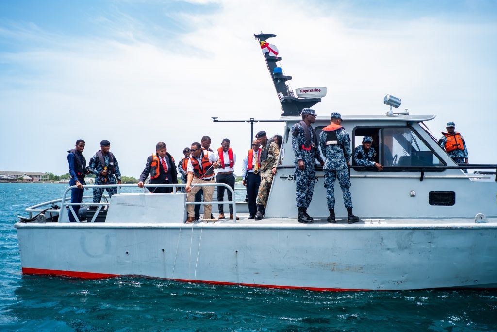
Header: Acting Senior Director of Surveys at the National Land Agency (NLA), Major Patrick Aiken (centre), converses with Colonel Adjutant Quartermaster of the Jamaica Defence Force (JDF), Captain (Naval) David Chin Fong (right), following the signing of a memorandum of understanding to facilitate hydrographic surveys of Jamaica’s seabed. Affixing his signature to the document is Lt. Col. R. Tyndale of the JDF, who signed as a witness
Insert: British High Commissioner to Jamaica, His Excellency Asif Ahmad (third left), observes as Kenre Valentine of the Maritime Authority of Jamaica demonstrates the use of the hydrographic survey equipment on a Jamaica Defence Force vessel that has been fitted with the apparatus to facilitate underwater surveys by the National Land Agency.
Photos Contributed

By Deandrea Hamilton
Cheaper shipping. Lower energy costs. Better access to healthcare. Stronger consumer protections.
Those are among the measures CARICOM Heads of Government believe could finally begin reducing the stubbornly high cost of living for millions of people across the Caribbean.
Meeting in Saint Lucia, regional leaders agreed that making life more affordable must become one of the Community’s highest priorities. Their emerging strategy includes reducing freight costs through a regional ferry service, accelerating renewable energy projects to lessen dependence on imported fuel, expanding regional healthcare partnerships, strengthening consumer protection, and encouraging governments to adopt successful cost-of-living measures already being implemented across the Caribbean.
“Our discussions over the past four days were guided by one central objective – ensuring that CARICOM delivers results that people can see and feel in their everyday lives,” CARICOM Chairman and Saint Lucia Prime Minister Philip J. Pierre said.
Few places may welcome that relief more than The Bahamas and the Turks and Caicos Islands.
Although inflation has moderated in both countries from the sharp increases experienced following the pandemic, the cost of living remains stubbornly high. Families continue to complain about grocery bills that stretch household budgets, rising housing costs, expensive electricity, healthcare expenses and fuel prices that remain among the highest in the region.
Governments have responded.
In The Bahamas, successive reductions in Value Added Tax on selected goods and other targeted tax measures have sought to ease pressure on consumers. In the Turks and Caicos Islands, the Government this weekend opens applications for its $500 Cost of Living Relief Programme, acknowledging that many households continue to struggle despite the country’s economic success.
Yet affordability remains elusive.
The contradiction is difficult to ignore.
The Turks and Caicos Islands continues to post one of the region’s strongest tourism-driven economies, with robust investment, record visitor spending and sustained construction activity. The Bahamas has also strengthened its economic position, earning improved sovereign credit ratings as tourism, government revenues and fiscal performance continue to recover.
Yet those encouraging economic indicators have not translated into noticeably lower household expenses.
The reason is largely structural.
Both The Bahamas and the Turks and Caicos Islands produce relatively little of what they consume. Food, fuel, medicines, vehicles, building materials and countless household essentials are imported. Both countries also record significant trade deficits, illustrating their dependence on overseas suppliers. Every increase in global shipping costs, fuel prices or supply chain disruptions is eventually reflected in supermarket prices, utility bills and the cost of everyday living.
That is why CARICOM’s agenda matters.
If regional leaders succeed in lowering freight costs through an inter-island ferry network, expanding renewable energy, improving regional cargo movement, strengthening consumer protections and making healthcare more accessible through cooperation, the benefits could extend far beyond government balance sheets.
For Bahamians and Turks and Caicos Islanders, success will not be measured by another tourism record or another credit rating upgrade. It will be measured at the supermarket checkout, on the monthly electricity bill, at the gas pump and in the simple ability to afford a better quality of life.
Caribbean News
From Pathways to Investment: Tackling the US $6 Billion Food Challenge for the Caribbean
By Kenroy Roach
The Caribbean’s food systems challenge is fast evolving into a broader development challenge.
Despite decades of policy attention and investment, the region remains one of the most food import-dependent in the world, spending over US$6 billion annually. At the same time, countries continue to grapple with food insecurity, high rates of diet-related non-communicable diseases, climate vulnerability, and exposure to external shocks that can disrupt supply chains and drive up food prices almost overnight.
For Small Island Developing States (SIDS), food security has shifted from an agriculture focus alone, it’s about economic resilience, health, climate resilience and sustainable growth.
Recognizing this reality, Caribbean governments have elevated food systems transformation as a regional priority through the CARICOM 25 x 25 Plus Five Agenda, which seeks to reduce food import dependence while strengthening domestic production, regional trade, and resilience. Across Barbados and the Eastern Caribbean, governments have also developed National Food Systems Pathways that identify the investments, partnerships, and policy reforms needed to transform food systems and accelerate progress toward the Sustainable Development Goals (SDGs).
Yet one challenge has remained persistent: financing.
In the face of high levels of public debt and limited fiscal space, while public investment remains critical, Caribbean governments simply cannot shoulder the financing burden alone. Transforming food systems at scale requires mobilizing far greater private capital, alongside development finance and public resources.
This was the rationale behind the recent convened in Barbados.
The Forum brought together governments, investors, international financial institutions, private sector leaders, regional organizations, and the United Nations around a simple proposition: food systems should be viewed not only as a development priority, but also as an investable asset class.
A distinguishing feature of the innovative gathering was its focus on attracting private investment—particularly private equity, impact investment, and blended finance solutions capable of supporting businesses and infrastructure across food value chains. By helping enterprises access growth capital and connecting investors with scalable opportunities, the initiative sought to unlock financing that complements public investment rather than adding to already constrained public balance sheets.
A key outcome was the launch of a regional Deal Book comprising approximately US$320 million in investment opportunities across seven countries, spanning agriculture, fisheries, agro-processing, logistics, and strategic food systems infrastructure. The Deal Book created a practical bridge between capital seeking opportunities and opportunities seeking capital, while enabling direct engagement between governments, enterprises, and investors.
The results were encouraging.
Across four sector-focused deal rooms, participants explored investment-ready and near-investment-ready opportunities and discussed blended finance private equity, risk-sharing, and partnerships to advance projects toward implementation.
The Forum highlighted a shift in perspective: food systems are now seen as strategic drivers of economic diversification, resilience, competitiveness, and growth. Investments across production, processing, logistics, and distribution can strengthen regional supply chains, create new businesses, generate jobs, and reduce vulnerability to external shocks.
For the United Nations, this experience reinforced an important lesson.
Transforming food systems requires more than the technical expertise of individual agencies. It requires integrated solutions that connect agriculture, nutrition, health, climate resilience, trade, private sector development, and financing.
This is where the Resident Coordinator System plays a critical role.
Across Barbados and the Eastern Caribbean, the Resident Coordinator Office has united UN system capabilities around a common food systems agenda. Working with FAO, WFP, the UN Food Systems Coordination Hub, and other partners, the RCO has helped align policy support, technical expertise, partnerships, and financing with nationally identified priorities.
The Forum demonstrated this integrated approach by convening governments, investors, development finance institutions, private sector actors, and UN agencies around a common objective. It showcased the UN’s comparative advantage as a trusted broker capable of connecting development priorities with investment opportunities.
The Forum’s success will be measured not by dialogue generated, but by investments mobilized, businesses expanded, and progress made toward resilient, competitive Caribbean food systems across the Caribbean.
Its most important outcome may therefore be what comes next.
The work starts now.
Kenroy Roach is Head of the UN Resident Coordinator Office for Barbados and the Eastern Caribbean

Deandrea Hamilton | Editor
What if we rejected the notion that Haitians flourish best only when they are outside of Haiti? What if the next great Haitian success story is not another exodus, but a hearty homecoming? For years, the conversation has been steered toward ushering Haitians out of Haiti. Having witnessed the indomitability of the Haitian people, I feel compelled to point out that a U.S. Supreme Court decision may force us to see what has been staring us in the face all along: the solution may be hundreds of thousands of Haitians themselves.
As thousands of Haitians in the United States prepare for the end of Temporary Protected Status (TPS)—a humanitarian programme created under U.S. law as a temporary protection, not a permanent immigration pathway—the conversation should extend beyond American immigration policy. It should turn to Haiti’s future.
History offers perspective. An estimated 20,000 to 30,000 Haitian revolutionaries defeated Napoleon’s forces and secured independence in 1804, making Haiti the first Black republic and the second independent nation in the Western Hemisphere. Now imagine the force of more than 300,000 Haitians returning with skills, discipline and experience gained in the world’s largest economy.
Add to that, Haiti is itself sending a clear message: the country needs its people.
I found a report from the Armed Forces of Haiti (FAd’H) which recently announced that 17,722 applicants came forward in just 11 days during its latest recruitment campaign. A second recruitment phase is planned and will specifically target professionals in law, engineering, medicine and other technical fields, as the country works to strengthen institutions, restore security and prepare for the future.
Coincidentally—or perhaps providentially—many of the Haitians now facing the end of TPS are not returning empty-handed. They include thousands of nursing assistants, caregivers, mechanics, delivery drivers, warehouse workers, agricultural workers, hotel employees, cooks, retail workers, security officers, landscapers, school assistants and property managers. They are returning with years of experience gained inside the world’s largest economy. They have learned trades, embraced innovation, worked within structured systems, met professional standards and developed the practical skills every successful nation depends upon.
These are not simply returning migrants. They may be the human capital Haiti needs most.
For generations, Haitians have become experts at surviving and thriving in other lands. They have endured political upheaval, natural disasters, poverty, insecurity and displacement with extraordinary resilience. But survival and escape cannot build their nation. At some point, survival must give way to rebuilding. And hope for home must command action. It requires people willing to invest not only in their families, but in the future of the country itself.
For decades, the Haitian diaspora has faithfully sustained families through remittances. That generosity has been indispensable. But rebuilding Haiti will require something remittances alone cannot provide. It will require human capital—teachers in classrooms, nurses in clinics, engineers on construction sites, entrepreneurs creating jobs, police protecting communities, judges strengthening the rule of law, and citizens committed to rebuilding the institutions that hold a nation together.
Anyone who has spent time in Haiti knows it is far more than the headlines. It is a nation of breathtaking mountains, secret waterfalls, fertile valleys and rice paddies. It is a land of remarkable creativity, deep faith, natural entrepreneurs, rich culture and resilient people. It is the oldest republic in Latin America and the Caribbean and the first Black republic in the modern world. Above all, it is a country worth fighting for.
Perhaps the fight itself now needs to change.
For too long, the world has defined Haiti by its crises. Haitians know it by its promise. The next fight should not simply be to survive, but to rebuild—to inject a new generation of skilled workers, professionals and entrepreneurs into a nation that desperately needs their mental muscle, their experience and their vision.
Returning home will not be easy, but what if returning became rewarding and the contribution of these thousands of Haitians became the catalyst for transforming or reforming the nation they call home?
No country can export its builders forever and expect to become stronger. Haiti has spent decades sharing its greatest resource with the world—its people. Perhaps the next chapter in Haiti’s remarkable story is not another exodus, but this very homecoming.
The next chapter of Haiti’s story should not be written at an airport departure gate, nor should it be framed only as horror for those whose TPS protections are ending. The real test now is whether advocates, attorneys, governments and the wider Caribbean do more than wave goodbye. We must help more than 330,000 Haitians find their footing, settle back in, put their skills to work and build the Haiti that generations of Haitians have always deserved.
Research & Development supported by ChatGPT AI


-

 Africa6 days ago
Bahamas’ Ghana Teacher Plan Draws Fire as Both Nations Face Shortages
-

 News6 days ago
Government Takes Case to Washington After U.S. Keeps TCI at Level 2
-

 News6 days ago
Ministry of Health Welcomes Appointment of New NHIB Chief Executive Officer and Highlights Progress of Organisational Transformation
-
 News5 days ago
Invest TCI Supports Certification of Local Flats Fishing Guides Through MSME Technical Assistance Under Historic TCFFA–TCICC Partnership
-

 News5 days ago
DDME’s Hurricane Hunt Scavenger Hunt Sparks Community Spirit and Storm Preparedness in Providenciales
-

 News6 days ago
PDM Alleges Governor ‘Bias’, Opposes One-Year Extension
-

 Bahamas News5 days ago
What 45 Shell Casings and New Murder Charges May Mean for Three Officers in the Azario Major Case
-

 Bahamas News6 days ago
CARICOM Targets Affordability as Bahamas, TCI Continue to Feel the Pinch