Connect with us

Weather

Forecast for The Bahamas and the Turks and Caicos for this afternoon and tonight, Friday 13th July, 2018

Published

on

#Nassau, July 13th, 2018 – Bahamas – GENERAL SITUATION: A TROUGH IN THE VICINITY OF THE NORTHWEST BAHAMAS EXTENDING FROM THE REMNANTS OF BERYL CONTINUES TO GENERATE UNSETTLED WEATHER ACROSS THE AREA WHILE THE REMAINDER OF THE ISLANDS IS UNDER THE INFLUENCE OF A RIDGE OF HIGH PRESSURE.


SPECIAL WARNINGS: BOATERS SHOULD CONTINUE TO REMAIN VIGILANT DUE TO THE POSSIBILITY OF WATERSPOUT ACTIVITY. HEAT INDEX WILL REACH INTO THE LOW TO MID 100’S SO IT IS ADVISED THAT OUTSIDE ACTIVITIES BE LIMITED AND DRINK PLENTY WATER TO STAY HYDRATED.


NORTHWEST BAHAMAS


WEATHER: A MIX OF SUN AND CLOUDS AND HOT WITH WIDELYY SCATTERED SHOWERS AND ISOLATED THUNDERSTORMS THIS AFTERNOON. SHOWERS AND THUNDERSTORMS WILL BE HEAVY AND STRONG AT TIMES. FAIR AND WARM TONIGHT.

ADVISORY: SMALL CRAFT SHOULD BE ALERT FOR GUSTY WINDS AND HIGHER SEAS IN OR NEAR HEAVY SHOWERS OR THUNDERSTORMS.

WINDS: VARIABLE AT 10 KNOTS OR LESS OVER OPEN WATERS.

SEAS: 3 FEET OR LESS OVER THE OCEAN.


CENTRAL AND SOUTHEAST BAHAMAS AND THE TURKS & CAICOS ISLANDS


WEATHER: MOSTLY SUNNY AND HOT WITH THE CHANCE OF ISOLATED SHOWERS AND THUNDERSTORMS THIS AFTERNOON.  FAIR AND WARM TONIGHT.

ADVISORY: SMALL CRAFT CAUTION IN EFFECT FOR THE SOUTHEAST BAHAMAS.  SMALL CRAFT SHOULD BE ON ALERT FOR GUSTY WINDS AND HIGHER SEAS IN OR NEAR HEAVY SHOWERS OR THUNDERSTORMS.

WINDS: EAST TO SOUTHEAST AT 10 TO 15 KNOTS IN THE CENTRAL BAHAMAS AND EAST TO SOUTHEAST  AT 15 TO 20 KNOTS IN THE SOUTHEAST BAHAMAS AND THE TURKS & CAICOS ISLANDS OVER OPEN WATERS.

SEAS: 2 TO 4 FEET IN THE CENTRAL BAHAMAS AND 4 TO 6 FEET IN THE SOUTHEAST BAHAMAS AND THE TURKS AND CAICOS.


DAYTIME HIGH TEMPERATURE:       93F         34C

OVERNITE LOW TEMPERATURE:      77F         25C


SUNSET:          8:01PM                    SUNRISE:                 6:29AM SAT.

MOONSET:     8:46PM                    MOONRISE:            8:03AM SAT.


LOW TIDE:      1:36PM                   HIGH TIDE:              8:00PM

LOW TIDE:      2:29AM SAT.        HIGH TIDE:              8:23AM SAT.


WEATHER OUTLOOK: A TROUGH IN THE VICINITY OF THE NORTHWEST BAHAMAS EXTENDING FROM THE REMNANTS OF BERYL WILL LINGER IN THE AREA THROUGH SUNDAY WHILE THE REMAINDER OF THE ISLANDS WILL PERSIST UNDER THE INFLUENCE OF A RIDGE OF HIGH PRESSURE.

TROPICAL WEATHER OUTLOOK: AN AREA OF LOW PRESSURE, ASSOCIATED WITH THE REMNANTS OF BERYL, IS LOCATED ABOUT 300 MILES WEST OF BERMUDA.  THE ASSOCIATED SHOWER AND THUNDERSTORM ACTIVITY REMAINS DISORGANIZED DUE TO STRONG UPPER-LEVEL WINDS. THESE WINDS ARE EXPECTED TO BECOME EVEN LESS CONDUCIVE FOR SUBTROPICAL OR TROPICAL DEVELOPMENT OVER THE NEXT DAY OR TWO WHILE THE LOW MOVES NORTH-NORTHEASTWARD, AND ADDITIONAL DEVELOPMENT WILL BE LIMITED ONCE THE LOW REACHES COLDER WATERS BY SATURDAY NIGHT OR SUNDAY. THIS SYSTEM HAS A LOW CHANCE FOR TROPICAL CYCLONE FORMATION THROUGH 5 DAYS.


FORECASTER: ORSON NIXON/CJ


Continue Reading

News

Hurricane Season is Over but not before Record-setting storms Killed Hundreds and Cost Billions

Published

on

Garfield Ekon

Staff Writer


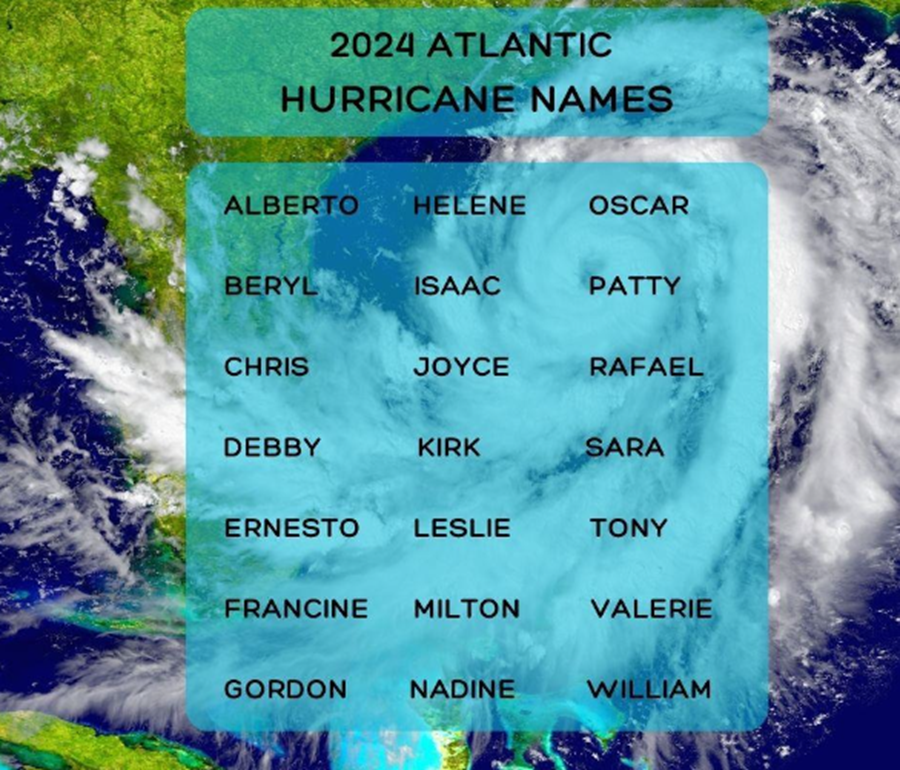
December 3, 2024 – The 2024 Atlantic hurricane season came to a close on Saturday, bringing to an end a season that saw 11 hurricanes compared to the average seven, and death and destruction hundreds of miles from where storms came ashore on the United States (U.S.)  Gulf Coast.

Meteorologists called it a “crazy busy” season, due in part to unusually warm ocean temperatures. Eight hurricanes made landfall, in the U.S., Bermuda, Cuba, the Dominican Republic and Grenada.

Hurricane Beryl became the first Category 4 hurricane on record to form in the month of June, slamming into the island of Carriacou in Grenada. In Jamaica it went on to destroy crops and houses and left two dead. The last time the island was scraped by a Category 4 hurricane was Dean in 2007, making it “pretty rare,” said Brian McNoldy, a hurricane researcher at the University of Miami.

The storm then intensified into the earliest Category 5 hurricane ever in the Atlantic on July 1. Major hurricanes — Category 3 and above — are not usually seen until September 1, according to the National Hurricane Center.

In September, Hurricane Helene caused catastrophic damage across the southeastern U.S. and was the deadliest storm to hit the U.S. mainland since Katrina in 2005. More than 200 people died. North Carolina estimates the storm caused at least $48.8 billion in direct or indirect damages with houses, drinking water systems and farms and forests destroyed. Florida, Georgia, South Carolina, Tennessee and Virginia also sustained extensive damage.

In October, Hurricane Milton rapidly intensified and the storm’s maximum wind speeds hit a screaming 180 mph, making it one of the strongest hurricanes by wind speed ever recorded in the Gulf of Mexico. The only one stronger by that measure was Hurricane Rita in 2005.

The areas where Helene and Milton struck saw as much as three times their usual rainfall for September and October, the heart of the Atlantic hurricane season. For Asheville, Tampa and Orlando, the two-month period was the wettest on record.

In November, Hurricane Rafael reached 120 miles per hour (MPH), and was nearly the strongest November hurricane on record in the Gulf of Mexico, tying with Hurricane Kate in 1985. Rafael made landfall in Cuba and battered the island as it was trying to recover from widespread blackouts caused by Hurricane Oscar in October.

Planet-warming gases like carbon dioxide and methane released by transportation and industry are causing oceans to rapidly warm. Several factors contribute to the formation of hurricanes, but unusually warm oceans allow hurricanes to form and intensify in places and times we don’t normally anticipate, McNoldy said.

“In other words, we never had a storm as strong as Beryl so early in the season anywhere in the Atlantic and we never had a storm as strong as Milton so late in the season in the Gulf of Mexico,” he said.

Continue Reading

News

Rain event brings Major Flooding, now PWD Assessing new Flood Prone areas

Published

on

Deandrea Hamilton

Editor

Turks and Caicos, December 2, 2024 – There was no tropical cyclone but hours of relentless rainfall in the Turks and Caicos on Wednesday November 27 exposed new flood prone zones forcing weather, disaster and public works authorities to issue alerts and warnings.

One to two inches of rainfall was in the forecast, but in waterlogged, low lying areas that meant more like two to three feet of water; a disaster for motorists, pedestrians and home owners, by 3pm Wednesday November 27, a flood warning was issued.

“WHAT…Intermittent rounds of showers and thunderstorms through tonight could result in localized flooding across much of the Turks and Caicos Islands. About 1 to 2 inches is possible for much of the area.  WHERE…Providenciales: Lower Bight, Along Leeward Highway (near Cash N’ Carry, Business Solutions, Do It Center, Caicos Lodge), Downtown, Five Cays, Kew Town, Millennium Highway, Industrial Drive, Long Bay. Middle Caicos: Northern parts of Conch Bar, Bambarra, Lorimers. North Caicos: Kew Settlement, Whitby, Sandy Point, Bottle Creek. Grand Turk: Waterloo, Palm Grove, West Road, Cockburn Town, Back Salina, Overback, North Creek.  South Caicos: Town/The Flats, Airport Road, Old Airport Road.”

The information supplied by the Turks and Caicos Weather Service impacted all major islands and was also distributed by the TCI Department of Disaster Management and Emergencies.

Videos and photos of the accumulation of water in areas of Providenciales were captured and shared on social media.  From a young man caught on camera surfing through the murky rain water to at least one vehicle being covered, almost completely, it was a soggy start to the Thanksgiving Holiday weekend.

“The Public Works Department, within the Office of the Deputy Premier and Ministry of Physical Planning and Infrastructure Development wishes to inform the public of ongoing efforts to mitigate the impact of recent heavy rainfall and localised flooding.

Overnight, the department conducted extensive flood-reducing measures in several vulnerable areas to ensure the safety of residents and maintain accessibility to essential roadways and infrastructure. Vulnerable areas currently receiving assistance are Long Bay, Long Bay Hills, and Leeward Palms on Providenciales,” said a Department statement issued on Thursday.

The weather service had warned that the flood alert would remain in effect until Thursday 9 a.m.

“Key measures undertaken overnight includes the installation of drainage wells where PWD crews worked tirelessly to achieve this.  These drainage wells will facilitate water flow and reduce flooding. Additionally, stationary pumps were active and mobile pumps deployed to flood-prone areas to divert accumulated water and prevent overflow.”

For those experiencing the inundation due to the rain event, there was exasperation.  Years of flooding in the same areas, with often identical remedies being reported generated calls for adequate drainage to be installed.  Some saying, the idea of wells was not working

Damage to homes and other properties including farms has not yet been made available, but there was concern for recent road repairs.

The Public Works Department assured residents that there was active response, assessment to determine if there were new flood areas and deployment of resources to clear roadways and neighbourhoods of water.

Continue Reading

Caribbean News

Hurricane Warnings on for many as Tropical Strom Raphael takes aim

Published

on

Garfield Ekon

Staff Writer


November 5, 2024 – A hurricane warning has been issued for the Cayman Islands and lesser alerts for parts of Cuba and Jamaica, as a weather system being monitored in the Caribbean developed into a tropical depression Monday morning.

The system was forecast to continue strengthening, the National Hurricane Center said, potentially becoming a tropical storm by the end of the day and a hurricane by Wednesday. Currently, Tropical Storm Raphael is moving at NW at 13 mph with tropical storm form winds extending outwards, 105 miles, from the centre.

The hurricane center said in an advisory Monday that the system was expected to approach the northwestern part of Cuba around the time it reaches hurricane strength. “On the forecast track, the system is expected to move near Jamaica late tonight, be near or over the Cayman Islands on Tuesday, and approach Cuba on Wednesday,” forecasters said.

They wrote in an earlier advisory that the system “could be near or at hurricane intensity when it passes near the Cayman Islands and Cuba.” As of 4 a.m., Tuesday, the tropical storm was about 170 miles south of Kingston, Jamaica and 425 miles southeast of Grand Cayman in the Cayman Islands. It was moving with maximum sustained winds of 60 mph, the center reported.

Maximum sustained winds of 74 mph are needed for classification as a hurricane.

The Miami-based National Hurricane Center said the heaviest rainfall is forecast to occur over Jamaica and parts of Cuba through mid-week. Rainfall will likely be accompanied by hurricane conditions in the Cayman Islands by Tuesday afternoon, and, possibly, in western Cuba and the Isle of Youth on Wednesday. Tropical storm conditions were expected to arrive in Jamaica by Monday night.

“Rainfall totals between 3 to 6 inches with locally up to 9 inches are expected. Flooding could occur over portions of Jamaica and Cuba, with mudslides possible,” the center noted. Heavy rainfall will spread north into Florida and adjacent areas of the southeast United States in the mid-to-late week, the center said.

“Models are in disagreement of where it will track after it reaches the Gulf,” Nolan says, “but the Gulf coasts from Texas, Louisiana, Mississippi, Alabama and Florida need to be on alert for impacts at the end of the week.”

Continue Reading

FIND US ON FACEBOOK

TRENDING