Weather
TD #9 gets a name; Tropical Storm Isaias forms packing 60mph winds

#AtlanticBasin – July 30, 2020 – Tropical Depression number nine, forecast to become the earliest ‘I’ named storm in history has finally earned that name: Isaias. In the wee hours of Thursday morning, TD#9 evolved from a tropical depression to a Tropical Storm with wind gusts up to 60 mph.
The National Hurricane Center, at 2 a.m. informed that Puerto Rico should expect strong rain bands from the tropical storm which has triggered storm watches and warnings for at least 10 Caribbean region countries.

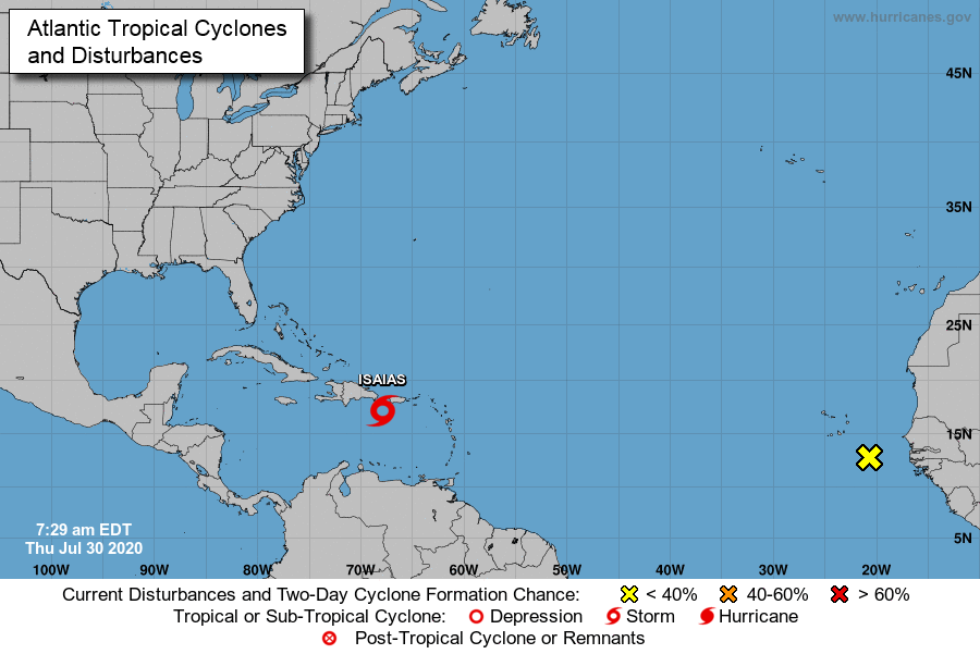
Tropical Storm Isaias slowed from racing across the region at nearly 30 mph to now pacing at 21 mph in a north-westerly direction. Hispaniola, home to Haiti and the Dominican Republic will experience storm conditions this morning and worse, the storm could become a killer.
“Isaias will produce heavy rains and potentially life-threatening flash flooding and mudslides across the Virgin Islands, Puerto Rico, the Dominican Republic, northern Haiti, and over the southeastern Bahamas.”
The Turks and Caicos Islands, which has been on Tropical Storm Watch since Wednesday at 12 a.m. has announced a national lockdown by noon Thursday and shelters are due to open at 4pm.
The southeastern Bahamas will experience conditions on Thursday afternoon and the central Bahama islands are predicted to shoulder powerful 60 mph wind conditions throughout the day on Friday.
“Tropical storm conditions are expected in the Central Bahamas beginning Friday morning and are possible in the northwestern Bahamas beginning late Friday.”


The National Hurricane Center advisory informs that British Virgin Islands, U.S. Virgin Islands, Puerto Rico, northern Haiti, Dominican Republic, Turks and Caicos and eastern Cuba will receive between three and six inches of rain.
Even higher rainfalls are forecast for The Bahamas; from four to eight inches. Life threatening surf and rip currents are expected from today due to approaching Tropical Storm Isaias.
“Swells generated by Isaias will be affecting portions of the Leeward Islands, the Virgin Islands, and Puerto Rico through today. These swells are forecast to reach the north coast of the Dominican Republic, the Turks and Caicos Islands and the southeastern Bahamas this morning.”
The National Hurricane Center, in the latest advisory informs:
The Tropical Storm Warning for St. Martin, St. Barthelemy, St.
Maarten, Saba and St. Eustatius has been discontinued.
SUMMARY OF WATCHES AND WARNINGS IN EFFECT:
A Tropical Storm Warning is in effect for…
* Puerto Rico, Vieques, Culebra
* U.S. Virgin Islands
* British Virgin Islands
* Dominican Republic entire southern and northern coastlines
* North coast of Haiti from Le Mole St Nicholas eastward to the
northern border with the Dominican Republic
* Turks and Caicos Islands
* Southeastern Bahamas including the Acklins, Crooked Island, Long
Cay, the Inaguas, Mayaguana, and the Ragged Islands
* Central Bahamas, including Cat Island, the Exumas, Long Island,
Rum Cay, and San Salvador
A Tropical Storm Watch is in effect for…
* Northwestern Bahamas including Andros Island, New Providence, Eleuthera, Abacos Islands, Berry Islands, Grand Bahamas Island, and Bimini
Interests in Cuba and the Florida peninsula should monitor the progress of this system.
A Tropical Storm Warning means that tropical storm conditions are expected somewhere within the warning area within 36 hours. A Tropical Storm Watch means that tropical storm conditions are possible within the watch area, generally within 48 hours.