
Weather
Florence and Michael retired by the World Meteorological Organization
March 21, 2019 – Florence and Michael won’t have another chance to wreak havoc in the Atlantic Basin.

The names of these two storms, which caused extensive fatalities and damage from Florida north to Virginia last year, have been retired by the World Meteorological Organization’s Region IV Hurricane Committee, which includes NOAA’s National Hurricane Center.
Storm names are retired if they were so deadly or destructive that the future use of the name would be insensitive – otherwise, names are reused on a six-year cycle.
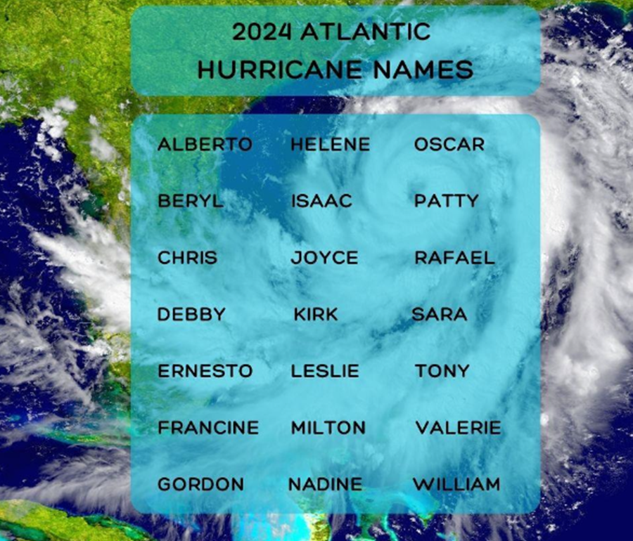
The committee also selected the replacement names for Florence and Michael as Francine and Milton, respectively. These names will first appear in the 2024 list of storm names.
Including these two, 88 names have been retired from the Atlantic basin list since 1953, when storms began to be named. The 2005 hurricane season has the most retired names – five – for one season.
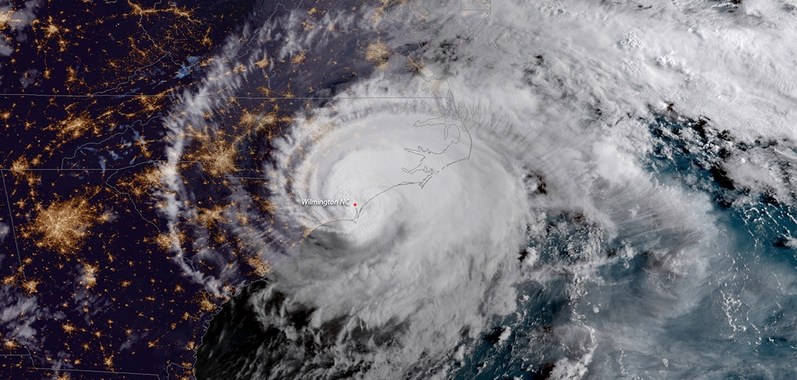
Hurricane Florence, one of the deadliest and costliest hurricanes to ever hit the Carolinas, made landfall near Wrightsville Beach, North Carolina, on September 14 and moved slowly inland with heavy rain, storm surge, and record flooding. It caused at least 51 deaths and produced extensive flooding across much of the Carolinas and Virginia.
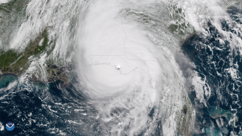
The next month, Hurricane Michael made landfall near Mexico Beach, Florida, on October 10, with sustained winds of 155 mph. This was the third most intense hurricane to make landfall in the contiguous U.S. based on central pressure, and the fourth most intense based on wind speed. It was also the most intense hurricane on record to make landfall along the Florida Panhandle, where it caused widespread devastation and farther inland across Georgia, the Carolinas, and Virginia. There were at least 45 fatalities blamed on the storm in the United States.
Header: Hurricane Florence makes landfall near Wrightsville Beach, N.C. at 715 a.m.
Release: NOAA
PRESS RELEASE
FROM THE DEPARTMENT OF DISASTER
MANAGEMENT AND EMERGENCIES
Providenciales, Turks and Caicos Islands, 9th April 2024 – The Department of Disaster Management and Emergencies (DDME) reminds the residents of the Turks and Caicos Islands that the 2024 Atlantic Basin Hurricane Season will officially begin on Saturday, 01 June, 2024, and end on Saturday, 30 November, 2024.
The Colorado State University (CSU) on April 4th, 2024, released its first 1st hurricane predictions for 2024, the outlook calls for an extremely active hurricane season with twenty-three (23) named storms, of which eleven (11) will be hurricanes with five (5) being major hurricanes. Colorado State has never predicted more than nineteen (19) named storms or nine (9) hurricanes in its initial forecast.
The extremely active season is being mainly guided by two factors:
- At present, there is record-breaking high sea surface temperatures across the North Atlantic Ocean. In February, sea surface temperatures in the tropical Atlantic had already reached historically high levels of about 1.2°C (2.2°F) above normal, from off the coast of Africa to off the coast of Central America; this region is considered the main development region for the Atlantic Basin tropical cyclones. (Tropical cyclones include depressions, tropical storms and hurricanes.)
The sea surface temperatures experienced in the month of February were more typical of that of warmer months such as June and July. (Warm oceans provide fuel to help tropical cyclones form, and boost their strength after formation.) However, the sea surface becomes warmer and warmer as the season progresses. Therefore, with such record-high sea surface temperatures already in place from West Africa to Central America, there is a likelihood that more tropical cyclones will develop and their strength boosted by this added fuel.
- The forecasters/experts have also advised that the El Niño-Southern Oscillation (ENSO) is transitioning from the El Niño phase experienced in 2023, to a brief neutral phase, then to a La Niña Phase. The La Niña Phase Forecast is anticipated to be fully in place by September 2024. Rain and increased moisture from the La Niña conditions could supercharge the season.
Kindly be reminded that it is the El Niño phase of ENSO that suppresses hurricane formation in the Atlantic Basin — since the El Niño generates more wind shear (winds changing winds with direction and height), which in turn suppresses the activity of hurricanes.
However, with La Niña the effects are the opposite — reduced wind shear, thus assisting hurricane formation and activity.
Thus, the experts are forecasting, anticipating, and expecting an above-normal supercharged 2024 Hurricane Season in the Atlantic Basin. Whilst in a normal season, there are approximately 14 named storms, 7 of which develop into hurricanes, of which 3 of these 7 develop into major hurricanes.
The National Oceanic and Atmospheric Administration (NOAA), will present their predictions on Thursday 23rd May, 2024 and CSU will release an update on Tuesday 11th June, 2024.
The Deputy Premier and Minister of Physical Planning and Infrastructure Development, with Responsibility for Disaster Management, Honourable Jamell Robinson encourages the residents of the Turks and Caicos Islands to commence their individual and family preparations; as the CSU has predicted an increased level of hurricanes that can potentially impact the Caribbean Region.
Hon. Robinson seeks to remind that the predictions would be more than we have experienced in the past years. Residents are urged to take proactive measures ahead of the 2024 Atlantic Season, as it only takes one storm to impact the TCI. As the Minister with Responsibility for Disaster Management, Hon. Robinson would like to implore individuals to take their individual and family precautionary actions so that our collective efforts of preparation for a major storm can reduce any potential impact.
Therefore, it is imperative that the residence of the Turks and Caicos Islands seriously begin their preparations, by inspecting their homes and making any necessary repairs, updating of their Family Plan and Insurance Policies. Ensuring that your Insurance Policies cover Flooding etc.
Remember Early preparation is the key!

Garfield Ekon
Staff Writer
#TurksandCaicos, March 22, 2024 – A severe weather warning for has been issued for the Turks and Caicos Islands, and The The Bahamas, where rainfall will effect the islands from Friday, March 22 to Monday, March 25.
According to The Bahamas Department of Meteorology, the combination of a “potent upper-level” trough, and unseasonably warm and moist conditions near the surface poses the “potential for squally/severe weather for the two countries.
The agency said in a statement on Wednesday that the three-day rainfall accumulations of 4 to 6 inches with maximum amounts of up to eight inches are likely in the Northwest Bahamas. Lesser accumulations of 2 to 4 inches are likely in the Central Bahamas and 1 to 2 inches in the Southeast Bahamas and the Turks and Caicos Islands.
It forecasted that the “highest risk” for squally/severe convection is expected from Friday evening to Saturday night, in the Northwest and Central Bahamas, and some street flooding and flooding of other low-lying areas, especially in the Northwest and Central Bahamas, is expected.
“Heavy downpours, localized flooding, strong gusty winds, dangerous lightning, hail and possible waterspout or tornadic activity may be expected during thunderstorms,” the agency said, adding that for the Northwest Bahamas, winds will be 20 to 30 knots, with gusts to gale force.
For the Central and Southeast Bahamas and the Turks and Caicos Islands, winds will be 20 to 25 knots with higher gusts. Small craft operators should not venture far from port in the Northwest and Central Bahamas on Friday,” the Met officed warned.
A small craft advisory will come into effect in Southeast Bahamas and the Turks and Caicos Islands on Friday.


-

 Caribbean News7 days ago
Barbados welcomes new aircraft
-

 News1 week ago
Young Junkanoo Player stuck in Grenada flown home on private jet by Government
-

 Finance1 week ago
E. Jay Saunders and Team spearhead landmark change in Public Financial Management; Budget ROLL-OVERS now approved
-

 Crime1 week ago
Males Charged with Firearm Offences
-

 Health1 week ago
Dengue Update – Brace for Potential Worst Dengue Season
-

 Crime1 week ago
Avoid Credit Card Fraud, CIBC makes security changes
-

 TCI News1 week ago
Fear that Horrible Airport Reviews damaging TCI Tourism
-

 Africa1 week ago
UN Sec Gen says Africans must be honoured, supports reparations